


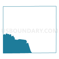
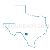
Voting District 0013, Uvalde County, Texas
About
Outline

Summary
| Unique Area Identifier | 677898 |
| Name | Voting District 0013 |
| County | Uvalde County |
| State | Texas |
| Area (square miles) | 250.36 |
| Land Area (square miles) | 248.98 |
| Water Area (square miles) | 1.39 |
| % of Land Area | 99.45 |
| % of Water Area | 0.55 |
| Latitude of the Internal Point | 29.16911240 |
| Longtitude of the Internal Point | -99.95701170 |
Maps

Graphs
Select a template below for downloading or customizing gragh for Voting District 0013, Uvalde County, Texas


Neighbors
Neighoring Voting District (by Name) Neighboring Voting District on the Map
- Voting District 0001, Uvalde County, TX
- Voting District 0001, Zavala County, TX
- Voting District 0002, Kinney County, TX
- Voting District 0004, Kinney County, TX
- Voting District 0004, Zavala County, TX
- Voting District 0007, Uvalde County, TX
- Voting District 0008, Uvalde County, TX
- Voting District 0009, Uvalde County, TX
- Voting District 0010, Uvalde County, TX
- Voting District 004B, Maverick County, TX
Top 10 Neighboring County Subdivision (by Population) Neighboring County Subdivision on the Map
- Uvalde CCD, Uvalde County, TX (23,148)
- Brackettville CCD, Kinney County, TX (3,598)
- Quemado CCD, Maverick County, TX (2,117)
- La Pryor CCD, Zavala County, TX (1,880)
- Batesville CCD, Zavala County, TX (1,232)
Top 10 Neighboring Place (by Population) Neighboring Place on the Map
Top 10 Neighboring Unified School District (by Population) Neighboring Unified School District on the Map
- Eagle Pass Independent School District, TX (54,258)
- Uvalde Consolidated Independent School District, TX (22,959)
- Brackett Independent School District, TX (3,598)
- La Pryor Independent School District, TX (1,913)
Top 10 Neighboring State Legislative District Lower Chamber (by Population) Neighboring State Legislative District Lower Chamber on the Map
Top 10 Neighboring State Legislative District Upper Chamber (by Population) Neighboring State Legislative District Upper Chamber on the Map
Top 10 Neighboring 111th Congressional District (by Population) Neighboring 111th Congressional District on the Map
Top 10 Neighboring Census Tract (by Population) Neighboring Census Tract on the Map
- Census Tract 9507, Maverick County, TX (9,412)
- Census Tract 9502, Uvalde County, TX (7,740)
- Census Tract 9503, Uvalde County, TX (6,519)
- Census Tract 9505, Uvalde County, TX (5,875)
- Census Tract 9501, Kinney County, TX (3,598)
- Census Tract 9502, Zavala County, TX (1,880)
- Census Tract 9501, Zavala County, TX (1,232)